Eilat is about a four hour drive south from Tel Aviv. To date, the farthest south we'd been was Qiryat Gat (where I work)--which is about an hour south of Tel Aviv. Needless to say, we were excited to explore the Negev desert, which essentially occupies the southern half of Israel.
Here's a visual of our journey to Eilat and the Red Sea. Just south of Kiryat Gat and Be'er Sheva, the Negev desert begins. We saw many Bedouin dwellings and apparently there are many camels. Also note the sign in the background...
This is a zoomed-in view of the sign. Portions of the Negev desert are used for military exercises since there's not much to get in harms way. We were sure to stay on the road.
About halfway to Eilat, we stopped at Ein Avdat National Park hoping to see the ancient Nabetean city ruins. We were surprised to find a canyon in which to hike, but no ruins. I asked around and was informed that the city ruins were down the highway another 10km or so.
We decided to save the hiking for another day, and headed south towards by car towards the ruins. Here's a view of the ancient city of Avdat which was founded by the Nabateans in the 2nd century BC. The city was located on the "Spice Route" that ran between the Arabian peninsula and the Gaza Port (on the Mediterranean Sea) via Petra (where we'd soon be visiting) and the Negev.
Nicki and Sammy enjoyed the ruins (not to mention the weather - it was 70 degrees or so...definitely not as hot as it looks).
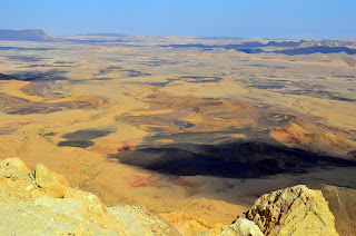
Our next stop was Makhtesh Ramon (or "Ramon Crater", which is a misnomer) just south of the town of Mitzpe Ramon. Ramon "Crater" is the world's largest Makhtesh, which is a geological formation unique to the Negev--being formed via erosion rather than impact from a meteor or volcanic eruption (more here for people like my dad who are interested in geology).
We soaked in the views for a view moments, and then ventured on, following the winding highway down into the makhtesh.
This picture was taken from the Mt Ayit viewpoint, somewhere between Mitzpe Ramon & Eilat. It gives indication of what the scenery looked like in all directions--presumably similar to what the Israelites saw as they wandered through the desert.
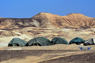
We saw several military outposts right off of the highway--usually a mix of the three T's--tanks, towers, and tents.
We also saw a handful of these dust-storm-like mini-tornadoes. This one was just north of the Hai Bar nature reserve--a refuge for Biblically menstioned animals such as the popular onagar and wild ass. We stopped at Hai Bar hoping to take part in the drive-through safari, but it was past 2:30 which is the latest that visitors can start the tour.
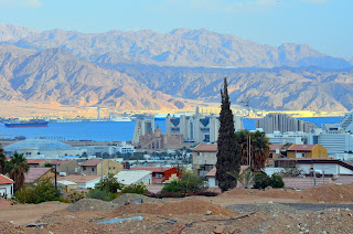
We made it to Eilat just prior to sunset. Here's a view of the town with the Red Sea and Jordanian mountains in the background. In fact, if you squint, you'll see the Jordanian town of Aqaba at the base of the mountains across the Red Sea.
By the way, you may notice that your Bible probably has a footnote that lets you know that the Hebrew name for this body of water was the "Sea of Reeds". We read that a typographical error during a mid-1700's Bible translation is why we now refer to it as the "Red" (as apposed to "Reed") sea. A case of the missing e.
You may also be interested in knowing that Eilat is mentioned in the Bible as one of the places the Israelites stopped during their wilderness travels (see Deuteronomy 2:8). Your Bible says "Eilath", but modern Hebrew no longer uses the "th" sound (similar to Bethlehem, which is prounounced more closely to Bet Lechem in modern times).
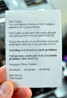
Since the sun was going down, we tried traveling along highway 12 to the Mount Yoash viewpoint. We'd read that nice views could be enjoyed there. After a few kilometers, a checkpoint blocked the road, and one of the guards told us that the road closed at 5pm (it was 4:45pm). He asked us where we were going, then let us go, indicating that Mt Yoash must be close. Here is a picture of a card he handed us as we drove away from the checkpoint.
We drove for a while, but never found Mt Yoash. Instead, we fixed our attention on the Israel-Egypt border. This fence & military road runs the length of the border on the Sinai Peninsula.
Below is another view of the border fence. I was standing on the main highway 12. The road pictured here was for Israeli Hummers and such. That's Egypt on the other side. After some border pics, we headed back to the checkpoint, being that it was now after 5pm and the stretch of road we were on was technically closed.
On the way back, the sun suddenly peeked through the clouds and lit up the landscape. At the same time, I spotted a turn-off (on the East side of the road) that looked like it might lead to a nice viewpoint. So, I pulled off and started winding up a bumpy, rocky road. Before making it to what seemed to be a viewpoint, I saw a military vehicle taking the same turn-off I had. Knowing that we were there past closing, I turned around and wound back down the gravel road towards the highway.
A jeep filled with four Israeli soldiers now blocked our path. Two of the men got out, machine guns strapped to their shoulders, and approached our car. After finding out what we were doing, they warned: "it is dangerous for you to be here". I politely asked why, and the friendly guard had trouble explaining. Nonetheless, we were on our way.
We crossed back through the checkpoint, back onto "safe" ground--and there was Mt Yoash! We had been distracted by the checkpoint when looking for the viewpoint, so had apparently missed the sign pointing to the pull-out.
After all that, here is the view we were looking for. By this time, the sun was down--but it was still neat to view the Red Sea, Jordan, and even Saudi Arabia (on the far right, across the water is the Saudi Arabian peninsula).
Finally, we made it to the hotel and Sammy got busy exploring while stretching his legs after the long journey. Little did he know he'd be going for his first pool swim in the morning.
Oh, and here's a bath-time pic I had meant to add to the last blog. This is from a month or so ago...but I couldn't resist including it.


I certainly enjoyed reading your interesting commentary and looking at your marvelous pictures. The scenery was amazing, but not as amazing as the pictures of precious Sammy. Thanks for posting.
ReplyDeleteLove reading your updates! Thanks! Vicki
ReplyDelete